Archive | September, 2013
September 27, 2013

Gilgit & Hunza

When glacier hiking, if you don’t put sunblock on the bottom of and inside your nose, your nostrils will burn from the sun reflecting off the glacier. Good to know, right? I found this tip in the Pakistan Trekking Guide.

Gilgit is nothing special. It’s a dusty town with not much going on, just a jump-off point to the real North. My only goal here was to buy a few items, namely a watch, a warm cap that can cover my ears, sunglasses, and hiking boots and pole. After Gilgit there are no large towns and therefore no large markets so shopping is best done here.

My feature-rich Suunto Core watch (altimeter, barometer, compass, thermometer, depth meter, sunrise/sunset times) had just come back from repair (free under warrantee) but was with Colleen in the US. All my other watches were in a safety deposit box in Arlington, except for one that draws way too much attention to consider bringing. So what watch did I buy in Gilgit? I’m not proud to say this, but I bought my first fake watch, and of all things it was a Casio knock-off, but with a very special twist (I’ve never seen anything like it – video forthcoming). This set me back $1.90. Next I bought sunglasses for 75 cents. “Oakleys” were going for the same amount but after the Casio, I wanted to keep it real, so I got a brand called “hot buttered”. Why not? For warm cap, I got a handmade wool Chitrali topi for $3.80.

For hiking boots and pole, I went to a second hand shop. I wanted something durable to last me through both Pakistan and Nepal so buying the cheap local or low-quality Chinese stuff didn’t make sense. Instead I bought from stock left behind by past trekkers/climbers, second hand but of high quality. I found a pair of boots of the brand name “Meindl”, which I’d never heard of, but they oozed quality and felt comfy on my footsies so I sprung $19 for them. I searched for them online and found that they’re made in Bavaria (a good sign) and retail for $200-500. Score! There were no used hiking poles so I bought the nicest new one I could find and that cost $10.

With shopping done, I headed to the local Aga Khan Rural Support Program (AKRSP) office to meet the team there. We discussed their current portfolio of projects including value chain development for the precious and semi-precious gems sector, electrifying remote villages with micro-hydro and solar PV, and youth and entrepreneurship development, among many others. AKRSP is the largest NGO by far in the Northern Areas and the one I’m consulting for on a different environmental project. While outside the scope of my engagement, it was fascinating to discuss high-level regional strategy with the management team. We basically did a rudimentary SWOT analysis for some of the more important projects and I respectfully shared a few observations and suggestions based on my experience doing similar work. The team was incredibly receptive to my inputs which made me feel great, but upon further reflection, it’s quite possible they were just being kind to the chubby burger kid from Karachi. For non-Pakistanis, burger is slang for rich westernized buffoon from the city.

I took a public minivan to Hunza in the evening. It was one of those annoying ones that leaves as soon as it’s full, however long that takes. I wound up waiting 80 minutes and then was crammed into a 12 seater with 17 other people (luggage and two people on the roof). I guess that’s why it only costs $2.60 for a 2 hour journey. In Hunza, I checked into the Hunza Embassy – $15 for double room including breakfast AND FREE WiFi! Woohoo!

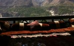
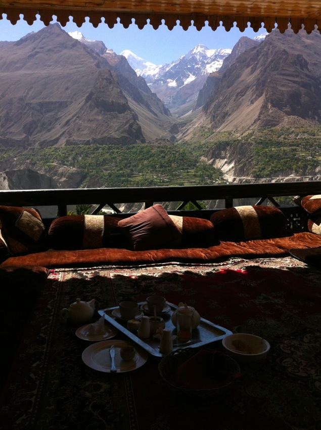
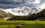
I woke up the next morning to glory! The view made my heart sing glory glory hallelujah! I arrived in the night so had no idea what was I was surrounded by, which as it turned out was natural awesomeness – green pastures with grazing animals surrounded by humungous snow-capped peaks that shone in the warm sunshine. It seemed the whole valley had a halo, and off course, a river ran through it. Hunza is spectacularly beautiful! Here is a picture of my breakfast spot. In the background you can see part of Rakaposhi (25,551 ft), the 27th tallest mountain in the world.

20130927-115247.jpg
The locals speak a language called Burushaski and many of them are descendants of soldiers from the armies of Alexander the Great who left many men behind in the area. The sale of cigarettes is banned. Electricity is rationed on a set schedule, outside of which hotels and a few big businesses run generators and everyone else burns kerosene lanterns.

I didn’t do much the first day, just walked around town, crossed the river over the Ganesh bridge (the name a legacy from Hindu times) and checked out some animist rock carvings from the 2nd century AD. There are two historical forts around town. I’m going to check those out tomorrow and also do some hiking with my large pack to build endurance and acclimate to hard physical exertion at this altitude. So far I’ve been ok but I did get a headache after an uphill segment today, which I’m still feeling. Unlike in Cusco, I have no Coca tea to help with the altitude sickness, although I have been drinking the local herbal tea called Tumuro and it’s quite delicious, whether or not it helps with altitude sickness.

I’ll post again in a day if my next hotel has wifi but after that there’s going to be nothing for two weeks as I’ll either be on a glacier or in Shimshal, the highest village in Pakistan, and they don’t even have phones up there.

September 25, 2013

The Highest Highway: The road to Gilgit

I got picked up at my uncle’s house in Islamabad at 10:40pm (40 minutes late) in a 90′s Toyota Landcruiser. My driver, the reincarnation of Speed Racer, drove with such reckless abandon around blind turns that I began mentally preparing myself for an accident. My seatbelt stayed on the entire night.

We passed through now infamous Abbottabad (actually a nice town) and made a quick tea and bathroom stop shortly after passing Mansehra. Driving through Chilas in the dark, we turned left on the Karakoram Highway (KKH). The KKH is the highest paved road in the world and runs 1,300km through Pakistan and China. It is sometimes referred to as the 8th wonder of the world.

Shortly before dawn we stopped at a trucker’s stop constructed of mud and corrugated metal. Inside there were two truck drivers asleep on thin mats placed on an elevated platform. They were so tightly wrapped in blankets that they resembled mummies. At this point we were only 1.5 hours from the Babausar Pass (13,700 ft) so it was quite cold. We huddled around the mud oven and chatted with the proprietor and his son for a while before ordering breakfast. The air inside was thick with smoke from the wood burning oven. I remembered a project I briefly worked on in Guatemala in 2008 where these type of ovens were being replaced with a new design that dramatically reduced indoor air pollution and respiratory illnesses. Breakfast was fried eggs with paratas and chapatis, and lots of tea. We ate sitting cross legged on the platform next to the mummified truckers. Not only was it delicious, but at $3.80 for 4 people, extremely cheap. Just like with a tea stop we made earlier, one of the passengers paid for the whole group. I was impressed with and touched by the friendliness, respect and generosity with which the 3 other passengers treated each other and me, sharing snacks, cigarettes and gum. These were good people.

Shortly after driving over the Babusar pass, which offered a breathtaking panorama of the Kaghan valley, I got my first glimpse of Nanga Parbat. I felt like a newborn, in that my testicles retracted back into my body, and they did so with the speed of a mantis shrimp punch (fastest punch in the natural world). So fearsome a sight was the 9th tallest mountain in the world that any aspirations I had of doing serious mountaineering evaporated in that instant. Only a madman would want to set foot on that tremendous mass of death. From the craggy ridges near its peak hectares of ice sheets are blasted into the surrounding sky by pulverizing winds. It looks peaceful from afar but anyone with a sense of scale will realize that cold merciless fury resides above and to meet it would mean a miserable and hopeless death.

20130926-022053.jpg
The KKH near Gilgit was buzzing with activity. We passed dozens of crews clearing rockfalls and repairing damage to the road from recent earthquakes. The region is earthquake prone as it sits on the collision zone between the Eurasian and Indian plates. When India separated from Africa 140 million years ago (when it was part of the supercontinent Gondwana together with modern Africa, Australia, Antarctica, and South America) it made its way NNE with a slight counterclockwise rotation until it hit Eurasia. India was moving at 20cm/year, extremely fast for a tectonic plate. When it collided with Eurasia around 50 million years ago, it formed the Himalayas, the most awesome mountain range in the world.

But back to the roads – not only are they being repaired but they’re also being widened 3x to facilitate greater trade volume with China, especially as efforts are underway to connect the Gwadar Port (which just got struck by its own earthquake yesterday that apparently created a new Island nearby) to Lhasa, which is already connected to Beijing by rail. China is very keen on this happening and it shows. Chinese text can be seen on machinery or tents at just about every other worksite along the highway, signifying their involvement on the Pakistan side of the project.

Arriving in Gilgit at 1:00pm, I checked into the Madina 2 hotel ($18 incl bfast). This was me treating myself as acceptable rooms with private baths were available for $7 at two other places. But because of how shitty I felt after the 14 hour road journey, and the fact that we are at this point waaay under budget on our round the world (RTW) trip, I decided to go upscale. And then I fell into the longest sleep I’ve had in a long time.

Tomorrow we go equipment shopping in the Gilgit market!

September 23, 2013

Winter is coming and the night is full of terrors – Northern Areas of Pakistan

In a few minutes I leave on the 13 hour drive from Islamabad to Gilgit, the frontier town that serves as capital of the Northern Areas. It will be my jump-off point into the autonomous Northern Areas of Pakistan. Marco Polo, this website’s namesake, when travelling near here in the 13th century called the area “noisy with kingdoms”, the better situated of which grew rich from taxing traffic to and from China. Gilgit has had many owners over its thousands of years history. It has been a part of Tibet, China, Afghanistan, the British Empire, itself (The independent Republic of Gilgit existed for a brief time following partition) and of course now belongs to Pakistan (kind of). This has led to many religious, cultural and linguistic traditions being layered one upon the other. The animism of the early inhabitants gave way to fire worship brought from Persia, which gave way to Hinduism (~1,700 BC), which gave way to Buddhism (4th to 11th century AD).

When Mohammed bin Qasim’s Arab forces invaded India (including modern day Pakistan) from the South by sea in 632 AD, he succeeded in the South but his forces were repulsed in the North. It was not until after the 15th century that Islam became the dominant religion in Gilgit, brought by the Sunnis who spread up the Indus River from Swat and the Shias who spread into Baltistan from Kashmir.

The King of Hunza converted to the Ismaili faith (followers of the Aga Khan) in the early 19th century and so there are also many Ismailis present in the area today. If you hear anyone speak of “His Highness” in these parts, they are referring to the Aga Khan – a playboy Briton living on a lavish historical estate in France who is in the process of finalizing his divorce from a German aristocrat (my mother attended their wedding reception) for cheating on her with an air stewardess – I know, it’s weird, but he is their pope and his philanthropic foundations spend over $600 million/year worldwide.

From 1947 (when both Pakistan and India won their independence from the British) to 1972, the seven feudal kingdoms along the Gilgit and Hunza rivers remained essentially autonomous, but between 1972 and 1974, they were properly incorporated into greater Pakistan and the Pakistani government took over, establishing five administrative districts.

Despite 100% of the modern day inhabitants of the region being one kind of Muslim or another, pre-Islamic planting and harvesting ceremonies have survived and most people still believe in fairies, witches and Jinn (ghosts capable of magic, kind of like invisible wizards). The town marketplace is a babble of languages as exotic as they are indiscernible. Punjabis, Pathans, Chitralis, Tajiks and Chinese Uyghurs trade side by side.

Despite having all this wonderful diversity around, the Sunnis of the region somehow still feel the need to attack and kill the Shias. They occasionally ambush and board buses on the isolated mountain roads, shooting any Shias they find on them. This made me revise my driving plan up to Gilgit so that I’m now taking the long way just to avoid Sunni areas. While I’m a Sunni myself, I don’t know if I could emotionally deal with anyone on my bus being murdered for their faith. I’d either get killed myself for trying to intervene, or more likely live with nightmares and depression for the rest of my life for letting it happen. Among the Sunnis of Pakistan is a large cadre of assholes who never cease to amaze with their ignorant hatred. The Shias, Christians and other religious minorities of Pakistan won my respect a long time ago for never responding with reprisal attacks. May their patience and restraint be rewarded in the near future with peace and security.

At the last minute before my flight from Karachi to Islamabad my mother urged me not to go to the Northern Areas out of fear for my safety and is to this minute asking me to reconsider. The way I saw it, I was trying to be hardcore but she wasn’t letting me – I felt like Jorge below.

(taken from a Mexican Jerry Springer-type show)

(taken from a Mexican Jerry Springer-type show)

She wasn’t alone. My father, my wife and my in-laws also asked me not to go. I love and respect them all and ordinarily would go out of my way to keep them happy. In fact I came very close to capitulating, but in the end decided I had to do it (with extreme caution). In some bizarre way, it bothers me that I’ve seen so much of the world while seeing so little of my own country which is full of remarkable historical, cultural and natural beauty. The danger is there – there is no denying that. Even in peacetime, people die in car accidents (driving off the side of the mountain) or from rock falls or avalanches. The roads aren’t good and emergency response is often inaccessible. This treacherous terrain, often more vertical than it is horizontal, has many ways to kill. But in the end, this trip was decided in my heart, not my mind, so off I go. Wish me luck!

My original plan was to go to Concordia, the intersection of Baltoro and Godwin-Austen glaciers from which 4 of the world’s 14 “eight thousanders” (meters) can be seen, including K2, and then on to K2 basecamp. But since I missed the weather window for 2013, instead I’ll be hiking across the Batura Glacier (4 day trek), one of the world’s longest and largest, beneath the peaks of Batura (25,574 ft) and Passu (24,600 ft). I’ll also be doing consulting work with a local NGO, helping them with their reporting to donors and putting together a performance monitoring and evaluation plan.

P.S. – Won’t have laptop for next three weeks as I traverse Gilgit & Hunza valleys. Will post to blog upon return.